Nobabies.net
Contact me at info@nobabies.net. Do be patient.
AND THEN
Here are the major links:
Here are the papers.
Here are the summaries.
Here is the source code:
Source code for kinship and fertility part 1
Source code for kinship and fertility part 2
Source code for kinship and fertility part 3
Source code for kinship and fertility part 4
I have begun putting up talks on YouTube
YouTube links
YouTube video scripts March 6, 2018 and updates expected.
Here you may begin looking for Wild Surmise, beginning with wildsurmises.com.
Below are articles:
Open letter to Alexey Komov June 4, 2019
Movie 54 Prophesy 9 Dam collapse:
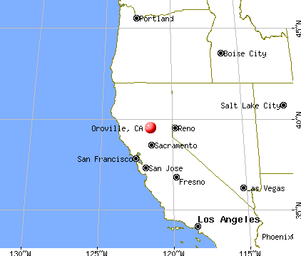
A couple of years ago last spring there was a crisis involving a dam near Oroville. I followed it a bit, and to my reading there was a division in the independent media with one side saying, “Everything is safe,” and the other saying, “Run for your lives. There was some good-natured name calling. For me to make sense of it all, I have to go way back in time.
Rocks form by sedimentation, volcanism and metamorphosis. They tend to be very strong and solid. When you are down to bed-rock you are where things are almost immune to disruption. That’s not always true. In Florida, bed rock is often limestone, which may be shot full of caves and risers. On the other hand, when I look at a major earthquake fault, it can look like it was made with a pizza cutter. No, I don’t know if pictures have been selected for that.
But if you look at the ravine walls at the Oroville dam, they look fragmented to me. It is as if they were shattered by some energy that would make an ordinary headline-worthy earthquake seem puny. My guess, only a guess, is that there was earthquake activity way back when that we can now hardly conceive of. Here is a map of the area:
https://www.google.com/search?q=oroville+california+map&tbm=isch&source=iu&ictx=1&fir=L2kCfbm3o9Y2dM%253A%252C_EBoqrkL2iH2wM%252C_&vet=1&usg=AI4_-kTJ1Ppw9TF5nY4uvjVlsbISbYqcpw&sa=X&ved=2ahUKEwj-uerYwNrjAhXHc98KHYU-BiEQ9QEwAXoECAQQBg#imgrc=L2kCfbm3o9Y2dM: July 29, 2019
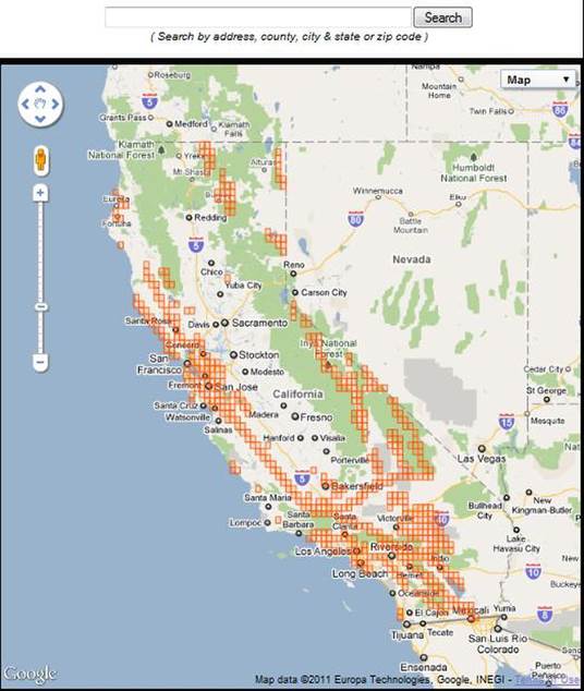
Oroville is just about due north of Sacramento just south of a little nubbin sticking into the Pacific. Here, then is a map of earthquake activity:
https://www.google.com/search?q=california+earthquake+fault+map&tbm=isch&source=iu&ictx=1&fir=LMKE9trGsIbDdM%253A%252Cteojt28ioKhY1M%252C_&vet=1&usg=AI4_-kQn4DBHCdGncbiliymtmmUJWQetUA&sa=X&ved=2ahUKEwiZp7fAv9rjAhVlTd8KHVoWBBEQ9QEwAHoECAcQBA&biw=1736&bih=886#imgrc=LMKE9trGsIbDdM: July 29, 2019
To my overheated mind, it looks like Oroville is not so far away, is in harm’s way. And indeed, earthquakes are reported in the area:
www.johnmartin.com/earthquakes/eqpapers/00000052.htm
by TR TOPPOZADA - 1982 - Cited by 23 - Related articles
The sequence included seven earthquakes of magnitude greater than 4.6 (Morrison and others, 1976). Faulting occurred on a northwest trending zone of the Foothills fault system (Hart and Rapp, 1975). ... Thus, the occurrence of the 1975 M 5.7 earthquake within 70 km of Oroville was not without precedent.
http://www.johnmartin.com/earthquakes/eqpapers/00000052.htm July 29, 2019
So maybe it’s not farfetched.
Skip forward a long way in time, and the Feather River cuts through this vulnerable landscape. California has very seasonal weather; I understand that there were times before the dam there that the river ran dry part of the year. So the setup was very good for a deep ravine to form and lots of the walls of the ravines being eroded going from broken rock to sand and then washing away. There was some gold in the rocks.
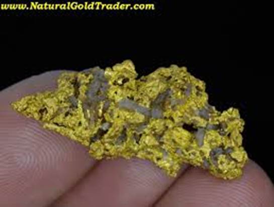
Gold does not react easily with other chemicals, so as it collects in rock it tends to be pure and to follow natural seams in very thin sheets. A bit of gold still in the rock can form a delicate, flower-like object. But break the rock up, releasing the gold, and the flower tumbling down a river can be beaten into a nugget, which is far more familiar.
https://www.google.com/search?q=natural+gold+in+rock+images&tbm=isch&source=univ&sa=X&ved=2ahUKEwi-tojYmOLjAhWGc98KHT_XD-0Q7Al6BAgDECQ&biw=1736&bih=886#imgrc=SN5Ff-VfhGZtmM: 8/1/19
Although the gold was too diffusely scattered within the rock to be economically worth mining, nuggets in the sand could be recovered by squatting with a pan and sloshing the sand off the gold. This was the basis for the Gold Rush. Sutter’s Mill, where it started, is about ninety to a hundred miles away. But Oroville must have been a pretty good location, since the name means Gold Town.
Skip forward another century or so, and it became evident that the seasonal rains in the north of the state would be valuable for agriculture in the south and so a search was evidently made for a nice deep ravine where a dam could be placed. On paper, Oroville must have looked splendid. Trouble was that the walls were … hmm … less than ideal. Boulder Dam in the south appears to me to be well set in solid rock. The dam was made of concrete, and I do not remember how long concrete was poured to create it.
It was decided to make the Oroville Dam out of mud. This is not unheard of, and the crumbling walls of the ravine may have left little choice.
Then a year or year and a half ago, a prolonged drought was broken by a lot of rain. The reservoir behind the dam filled, which was well and good, and power could be drawn with generators. One of those does not work, and I suspect it has not been replaced because for so much of the year there would not be enough extra water to justify it.
As the water piled up, the main spillway was unable to keep up. There were problems with the spillway, and only so much water could be diverted through the generator room. So the decision was made to use the “secondary emergency spillway,” which was supposed never to be used at all. It was a lowish bit of the dam and had a concrete apron to prevent erosion of the dam by water coming over the top. Well the water came and came, the apron was breaking up, a forest on the flank of the dam was washed down and it was quite the mess. A huge evacuation too place.
So they started using the main spillway, problems and all, and the water pretty much destroyed it. It was rebuilt over the next couple of years, but when I look at it I am reminded of the movie “Zorba the Greek.” Zorba attempts to have some logs sent down a cable with little wheels on the cable. But he makes no allowance for dispensing with the energy released. It does not end well. Similarly the rebuilt spillway runs straight as a die, until it falls over, yes, more fragmented rock.
Early this year they decided to test their work at 100%, but at 20% the spillway started throbbing (no, I am not an official speaker, I’m just relating what I heard), and they shut it down.
On the other hand, the secondary spillway has had what looks like more prudent attention. There are a number of giant stair-step pathways, which are scattered in such way as to encourage turbulent rather than laminar flow; and I feel better. We should be out of the woods.
For now.
But remember all this started, apparently, with one or more incredible earthquakes. If they return, evacuation will be most problematic.
If I ran the zoo, I’d say this just is not a good place to impound water; take the thing down.
Somebody in California politics has – I’m t0ld – suggested the state should be “re-wilded.” That means get rid of all the people, except I should imagine the super-rich and their servants to rejoice in a paradise.
YouTube video scripts directory
Home page